Waterfalls in Georgia
Most of the waterfalls in Georgia are found in the northern part of the state, including all the falls mentioned on this site. There are many great waterfalls to be found here, and some are in terrific backcountry settings. Lots of great hiking oppurtunities here in the beautiful southern Appalachians, so plan a visit. It took me many years to make it to Georgia, and I'm glad I finally took the time.
Cumberland Corner
Previously denoted as "Northwestern Georgia", I have now renamed this area because this area holds the branch of the Cumberland Mountains found in Georgia, in the very corner of the state near Alabama and Tennessee, where the Cumberland Mountains continue. Currently, I've only been to the incredible Cloudland Canyon, but one day I plan to visit the similarly impressive Lula Falls nearby.
Cloudland Canyon State Park
Description: Cloudland Canyon is a beautiful state park, located near the border of Alabama and Tennessee. The big disclaimer is that if you want to get to the base of the second big falls, you will have to tackle 600 stairs. Now, it's not as bad as you might think, but 600 stairs is still pretty daunting. There are five waterfalls in this park (according to me); park maps will say there are only three. All but one require going down at least a few hundred stairs.
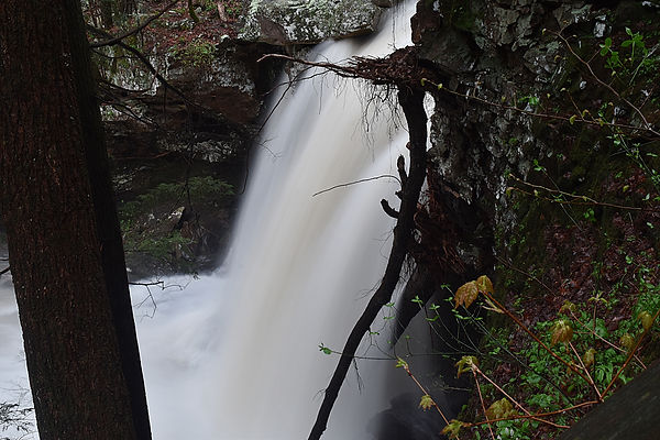
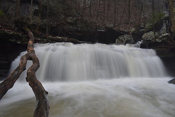
Hiking Description: Start at the parking lot here (34.834677, -85.480521). Head west on the trail towards the canyon rim, which is just 100 feet away. If you've come after rain, you can look across the canyon and see West Rim Falls, the only falls that you can see without hiking stairs, and also the only falls not on Daniel Creek. If you walk a bit to the right, you may be able to get a sneak peak of Hemlock Falls way, way, way down below, but it's mostly hidden by the canopy. There are some other good canyon views here too. Anyway, if you're ready to start the decent, head back towards the parking lot, and keep going straight when you get back to where the parking lot is now on your left. The trail is deceptivley easy at first, with just a few stairs here and there, but you are still staying atop the rim. After about .2 miles, you will reach a trail junction, and you will want to go to the right. This is where the trail begins to steepen, and the stairs will become a common sight. It's about 200 stairs to the split for Cherokee Falls, the first waterfall. This will be well marked, and will be on the left. The spur to Cherokee is pretty short, and is mostly flat. It's quite a view once you get there, and you can move around to get many perspectives. Once you're done here, head back to the main trail. Turn left, continuing down into the canyon. Pretty quickly, you will begin the largest set of stairs. The remaining 400 stairs are pretty much non-stop from here. Once you finally reach the creek, you're almost there. Turn hard left at the creek; this is the spur trail to Hemlock Falls. You may be able to see a bit of it from here. The trail is easy to Hemlock Falls, and ends in a large wooden overlook of the falls, very different from Cherokee. I prefer this waterfall to Cherokee, but they are both great. Once you've had your fill here, there is still more, and only a few more stairs! Head back to the split, and keep next to the creek, where you will shortly cross Daniel Creek on a large bridge. Once across, you will go down a short staircase, and get a view of an unnamed waterfall of about 15 feet, which I refer to as Bridge Falls (it's under the bridge). Best views are had by scrambling off trail, but this looked sketchy, so I didn't go off trail. Continuing just a short distance further, you will come to another unnamed waterfall, which I call Wide Falls (it's short and wide). Some easy scrambling leads to the best views. Continuing just a hundred or so feet beyond, you will come to a stream crossing. This is the stream that feeds that super tall waterfall you saw from the parking lot! You can't see much of it from here, but it's cool to see how far you've gone. Once you've accepted the fact that you've got to go back up those 600 stairs, get to it, and remember how nice the falls were. Luckily, the scenery is a good distraction from the stairs.
Total Mileage: 1.1 total
Difficulty: 7/10 (Moderate)
Date First Visited: March 31, 2021
Date Last Visited: December 31, 2021
Rank: A+

Cherokee Falls

Hemlock Falls
Bridge Falls
Wide Falls
West Rim Falls
Chattahoochee National Forest
The Chattahoochee National forest is a massive forest that encompasses much of northern Georgia, and hosts many waterfalls. There are many more falls than what's listed here, but I have been to most of the big ones, save for Amicalola and Anna Ruby. Do note that many of the falls here are located far from the beaten path on dirt forestry roads. These roads are usually in good condition, but it's something to keep in mind.
Crow Creek Falls and Minnehaha Falls
Crow Creek Falls:
Description: Crow Creek Falls is a scenic waterfall in the middle of nowhere. It is found along the very windy Crow Creek Road. I should first make some notes on this road. #1: It is gravel, but is is smooth and is passable in most any car. #2: You can save yourself a lot of stress by coming in from the south from Low Gap Road. The falls is a similar distance from the north at Burton Dam Road, but this way is much narrower. We came across a log truck on one of these narrow sections, and I had to literally back up a short distance to a slightly wider area so he could pass, and it was still very tight. The benefit of coming in from Low Gap Road is that the first mile and a half of the three miles you'll be travelling is paved, and the rest that is gravel is much wider then the sections closer to Burton Dam Road. However you get there, be prepared for no signs and little semblance of a parking lot.
Hiking Description: Park near here (34.774106, -83.523740). The trail starts just about 100 feet to the west of here right next to a small metal sign that says "End County Maintanence". The unofficial path is very skinny here, and goes up a short hill into the forest. Once up this small hill, the trail flattens some, and gets much wider. Follow for just 0.1 miles, and the falls will be down on your left. Getting down to the falls is a bit steep, but it's nothing terrible. Enjoy the solitude, as there is almost no shot of anyone else being here.
Total Mileage: 0.2 total
Difficulty: 4/10 (Moderate)
-----
Minnehaha Falls:
Description: Minnehaha Falls is a tall and wild looking waterfall at the end of a short trail. The road to get there is gravel, but should be passible to most vehicles. It is very near to Crow Creek Falls, and you could easily visit both in an outing. They are so close together in fact, that I have paired them into one entry. There really is no reason to visit just one. They're both easy and scenic!
Hiking Description: Park in a small parking lot here (34.749624, -83.479252). It kind of comes out of nowhere as you're driving, so be ready for it. It is on the north side of the road. The trail starts across the street on the south side, going up a staircase right off. Once you get to the top of this staircase, it will continue climbing. Most of this short trail is uphill, but it will get less steep as you go. As you near the creek, the trail gets a bit muddy, but isn't too bad, and as you round a bend, you will see the falls after just 0.15 miles.
Total Mileage: 0.3 total
Difficulty: 3/10 (Easy)
Date First Visited (all): March 14, 2024
Date Last Visited (all): March 14, 2024
Rank: A+

Crow Creek Falls

Minnehaha Falls
Helton Creek Falls
NEW!
Description: Helton Creek Falls is a towering falls that cannot be fully seen from the base. You may be able to see its true height while driving in if the trees are bare. I have actually been here before, way back in the summer of 2019, but I have no photos from then, so a second visit was in order. The trail is short, but scenic, first leading to the lower section of the falls, and then up to the main upper drop (pictured). The view is good from the deck at trails end, but it's even better from up close. The only way to get closer is to enter the creek and wade upstream. This is actually pretty easy. The stream is shallow and sandy, and it's a good time. The only issue is that on my visit, it was just 36°. This was not going to stop me however! I waded the creek and got very near to the falls, and it is spectacular. I also dropped my phone in the creek here, which was a true fumble on my part. It still works!
Hiking Description: Park here (34.753185, -83.894238) in the marked lot. The last 1.6 miles of the road (if coming from US 19) are gravel and it is bumpy, so go slow. The trail starts on the west end of the small parking area, quickly going down some well constructed stairs. The trail wraps to the left, and then you should see a short spur trail on your left. After a few stairs, it will end at the base of the lower falls in a sandy area. Looks like a great place for wading. Once you're done here, continue on the main trail, climb some stairs, and to the large wooden viewing deck for the big upper falls. It's easy to get into the creek and wade here too, if you'd like to get even closer, as I did. All of this is only 5 minutes from your car!
Total Mileage: 0.3 total
Difficulty: 3/10 (Easy)
Date First Visited: June 9, 2019
Date Last Visited: January 19, 2025
Rank: A+

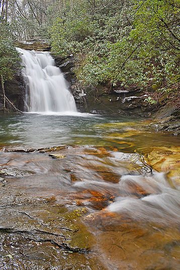
Hemlock Falls (Moccasin Creek)
NEW!
Description: There is another Hemlock Falls in Georgia, and while not nearly as big, it is scenic, has a great wading pool below it, and a pleasant hike. When I was here in January, there was snow covering almost the entire trail, which I was not expecting. It had snowed more than a week prior, and consistant warm weather still hadn't melted the snow here.
Hiking Description: Park here (34.847942, -83.596892) at the end of the short gravel road. The trail starts by going northwest, in the same direction you had been driving, now on a trail. The trail is flat and easy to traverse, and you will quickly begin to parallel Moccasin Creek. You will continue to follow the stream for the rest of the hike. The trail goes generally uphill, but it's at such a gentle grade that you can barely notice. Near 0.75 miles, you will cross over the creek on a footbridge. Following the bridge, the trail ascends some rock stairs, before entering a more rugged section. There are some washed out sections as you near the falls, but it's nothing awful. You come to the falls at 1.0.
Total Mileage: 2.0 total
Difficulty: 4/10 (Moderate)
Date First Visited: January 18, 2025
Date Last Visited: January 18, 2025
Rank: A-

High Shoals Scenic Area (2)
NEW!
Description: This is a tough one, but a good one. There are two waterfalls along the wonderful High Shoals Falls Trail: Blue Hole Falls and High Shoals Falls itself. The hike to the falls is already a 1.3 mile one-way descent of 550 vertical feet, but there's more. The road to get to the trailhead is closed sometimes, and you have to walk an additional 1 mile one-way up 600 vertical feet. If the road is closed, as it was when I was there, you'll have to first endure a grueling climb up the road, then descend all the way back down to the falls, and then back up to the road on your way out. It's pretty tough, but the trail is in good condition, and the road could be open at the time of your visit, making it even easier.
Hiking Description: Drive to here (34.822636, -83.734088), and see if there is a gate blocking the road. If it isn't, continue 1 more mile to the official trailhead. If it's closed however, you'll be parking here. Head out on the road, passing the gate, and ford the small stream. It's very shallow, but you will get your feet wet. This is the Hiawassee River, very near to its headwaters, and it's very small here. From here, it's all uphill to the trailhead. You will reach the beginning of the trail on your left after 1 mile. It immediately starts descending, past a kiosk and into the forest. After a tight switchback to the right, the forest gets particularly beautiful, and after a second switchback to the left near 0.5 miles from the road, the trail flattens as you near High Shoals Creek. At 0.6, you'll cross the creek on a large bridge. The creek is gorgeous here, and it looks like a great place to wade. From here, the trail continues descending, on down to Blue Hole Falls at 1.0. You will see the top of the falls from the trail, and then an unmarked, but obvious side trail on the left leads down a few stairs to a wooden observation deck for the falls. It truly is a blue hole, and it looks like a great place to not only wade, but swim. If you keep going down the main trail, it will steepen and go through multiple switcbacks to reach High Shoals Falls at 1.3 (2.3 if the road was closed). It doesn't look as tall or as powerful as it really is in a photo. You really have to see it for yourself. I found myself lingering here for quite some time because it was just so incredible. When you finally do leave however, it's a long, uphill hike back, so take it easy.
Total Mileage: 2.6 total (4.6 total if the road is closed)
Difficulty: 6/10 (Moderate)
Date First Visited: January 19, 2025
Date Last Visited: January 19, 2025
Rank: A+

High Shoals Falls (left) and Blue Hole Falls (right)
Long Creek Falls
NEW!
Description: Getting to Long Creek Falls is an adventure, but a worthy one. The hike is no issue-it's easy and scenic, but getting to the trailhead takes a bit more work. It's way out in the middle of nowhere on a maze of dirt forestry roads. I've found that the simplest way to get here is to come in is from the west, taking FS Road #58 from Doublehead Gap Road (34.708306, -84.220414). This is still 5.3 miles one way on dirt, and it's a bit bumpy in some areas, but it should be passible even is smaller cars. It's worth the effort however, as the falls is wonderful and the remoteness is kind of nice in a way.
Hiking Description: The trail heads northeast from the road, very near to Long Creek. The trail follows Long Creek all the way to the falls, but it cannot be seen for much of the hike. You are hiking on the combined Appalachian and Benton-MacKaye Trails, which are both cross-country trails (you may have heard of them, haha). The AT is blaze white. The trail starts flat, and then begins gradually ascending. It's a pretty gentle climb save for one steeper section near 0.6 miles. By the time you reach 0.85, you will come to a major trail junction. The Appalachian Trail goes right, the Benton-MacKaye Trail goes straight, and a signed spur trail to Long Creek Falls goes left. Take the left trail to the falls, which is blaze blue. After just a few minutes, this trail will end at Long Creek Falls 0.95 miles from the start. There is a large flat area to view the falls, and it's a very beautiful spot, so enjoy.
Total Mileage: 1.9 total
Difficulty: 3/10 (Easy)
Date First Visited: January 19, 2025
Date Last Visited: January 19, 2025
Rank: A+

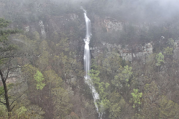
Toccoa Falls
Description: Toccoa Falls is a real giant and is not to be missed. It is a 186 foot free fall, and it is spectacular. The property is owned by Toccoa Falls College, which restricts the access to the falls, but not by much. It is open to the public 10a-4p M-F and 12p-4p on weekends, except when there are school functions taking place there (it never hurts to call first to make sure it will be open on the day of your visit). There is a $2 fee per person to enter, but it's more than worth it. One more thing I should mention is that Toccoa Falls is a rare example of a waterfall that looks good in the sunshine. Most waterfalls are best viewed in cloudy conditions so you don't get harsh shadows contrasting with the bright whitewater, but Toccoa Falls is in an open area where there are no shadows from late morning into early afternoon, and it looks really awesome in this light. My photos provided were taken on a day without a cloud in sight, and they are some of my favorites.
Hiking Description: Enter the gift shop, pay the small fee, and continue out the back door where the trail begins. Cross the patio and walk for a whole of 2 minutes before you get to the falls. Be sure to take some time to explore the various vantages, as its character can chage quite drastically. Look up and notice just how tall 186 feet really is. This is one of those places that everyone should see.
Total Mileage: 0.2 total
Difficulty: 1/10 (Easy)
Date First Visited: March 14, 2024
Date Last Visited: March 14, 2024
Rank: A++

