Waterfalls in Michigan
All but one waterfall in Michigan is located in the wild and often remote Upper Peninsula. I have been to Michigan only one time, and it was to the Upper Peninsula. I saw quite a few waterfalls on this trip, and every waterfall located on this page was shot during this single trip in June, 2023. The bugs are really bad here in the summer, which was an unfortunate surprise for me. On the flipside, the weather is fantastic, and many of the falls here flow through the summer from the enormous amounts of snow they get in the winter. Overall, it's a great area, and I will be returning someday.
Western U.P.
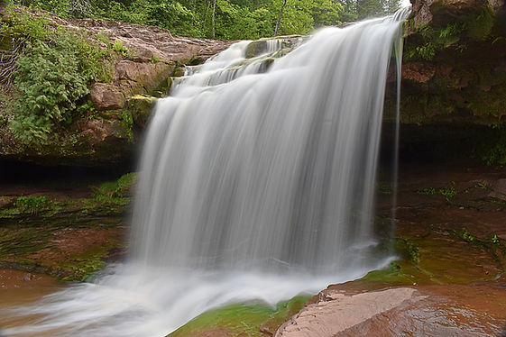
Agate Falls
Description: Agate Falls is the first waterfall I saw in Michigan, and it really set the stage for every other waterfall I would see. The bugs were insane, but the waterfall was awesome, which would be the story for the other falls I saw in the U.P. As for Agate Falls itself, it's really easy to get to the top, but you can't see much of anything from the overlook. Perfect views can be found from the base, but you'll have to work for it. The path to the base is steep and dangerous, and should only be attempted by those with good agility and balance. Nearby Bond Falls is an easy alternative for those who aren't up for this trek.
Hiking Description: Start at the marked Agate Falls Scenic Site parking lot on the south side of M-28. The paved trail starts out heading north and quickly goes under the M-28 bridge. You can see the river from here, and it's already pretty far down there, and you're still above the falls. Continue on the paved trail for just over a tenth of a mile to where it dead ends at the "overlook". You can't really see much of the falls from here, but there is a way down there. Backtrack a few feet and leave the pavement to your east (away from the river). The overlook is raised a few feet above the ground, and once off the blacktop, you will want to go under this structure, where you'll find a fence. Turn right/north, towards the waterfall, following the fence. There is no real trail here, but this makeshift path starts off easy enough. After a short distance, the fence will end, and there is nothing stopping you from falling down a steep hillside of 50+ feet, so please be careful here. The path will cut between some boulders in a cool squeeze, and will begin to steepen considerably. Past these boulders, any semblance of this bootpath starts to fade. You should see the falls by now, and see that you have actually passed it. You are still high above the falls, but not nearly as high as when you were at the overlook. Sometime soon, you will want to swing left and turn 180 degrees and start cutting diagnally down to the falls. There is really no path to follow here, and it will be up to you to find the best way. This is the hardest part of the hike, and it really does get steep, but there are trees to hang on to. Providing you make it to the base, you'll be glad you did, because the view couldn't be better. It looked like a great place to wade, but we were getting swarmed by bugs, so we opted not to.
Total Mileage: ~0.4 total
Difficulty: 8/10 (Difficult)
Date First Visited: June 5, 2023
Date Last Visited: June 5, 2023
Rank: A+

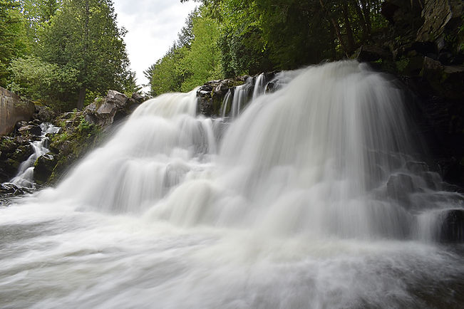
Bond Falls
Description: Bond Falls is on the same river as Agate Falls, a few miles upstream. It's much easier to get to. I personally prefer Agate Falls, but Bond Falls is a massive affair, and there are many cascades upstream of the falls that are quite scenic in their own right.
Hiking Description: Start at the Bond Falls Trailhead here (46.409705, -89.135049). The trail begins on the east side of the lot. The paed trail heads into the woods, and you will come to the falls after like one minute of walking. It's that simple. Once you approach the falls, you will come to a T intersection. I would reccomend going left first, which leads to many great views of the falls, and access to river level. If you continue on the trail, it will come to a bridge over the river, and the trail will dead end soon after, rather close to the falls. Once you've enjoyed all the views from here, backtrack to the split, and continue straight (what would've been right at the beginning). There will be one more access point to the river, and then the trail will go up a concrete flight of stairs, taking you within literal inches of the waterfall. Pretty amazing sight right there, and then if you continue up a few more steps, you will be above the falls. The trail continues on up the river, passing numerous scenic cascades and small falls. The trail is not paved past the stairs, and is a bit more uphill, but it's still easy. If you continue up this trail for 0.15 miles from the top of the staircase, you will come out at Bond Falls Road. You can either backtrack the way you came, or turn right and follow the road for a short distance back to the parking area road on your right. Either way is about the same distance.
Total Mileage: ~0.4 total
Difficulty: 2/10 (Easy)
Date First Visited: June 5, 2023
Date Last Visited: June 5, 2023
Rank: A

Bond Falls

Cascades Above Bond Falls (one of many)
O Kun de Kun Falls
Description: O Kun de Kun Falls is a very scenic waterfall in a pleasant backcountry setting. The hike is somewhat long, but it's really easy, and there are a few other sights to see there too. You can get really close to the falls with some effort, and it's pretty awesome.
Hiking Description: Start at the easy to miss trailhead located here (46.646886, -89.175374). Pick up the wide and flat gravel trail on the north side of the lot. The trail will head north before junctioning with the North Country Trail at a T intersection after 0.1 miles. Turn right here, following the signs for the falls. The trail will alternate between gravel and occasional boardwalks through boggy areas. After about 1.2 miles, you will approach the Baltimore River, and see a sign pointing off to the right to the Upper Falls. This is referred to as Peanut Butter Falls by many, and it can be found off this short, but steep bootpath. The views are very limited however, and it isn't very interesting as a result. See pictures below. Back on the main trail, The main falls is just a tenth of a mile further, 1.3 from the trailhead. You will arrive at the top of the falls, which is pretty scenic, but the best views are found from the base. The easiest way to get to the base is to continue down the trail a short distance to a bootpath on the right which leads into the trees. The short, but steep path will lead down to the river and falls at the base. You can get really close to the falls, and the view is perfect. From where you left the main trail, you can continue a short distance further to a large bridge over the Baltimore River and another view of the falls from further away.
Total Mileage: 2.6 total
Difficulty: 3/10 (Easy)
Date First Visited: June 5, 2023
Date Last Visited: June 5, 2023
Rank: A

Peanut Butter Falls
O Kun de Kun Falls
Powerhouse Falls
Description: Powerhouse is a scenic waterfall that is literally viewable from your car. If you do leave the vehicle however, you will find some great wading oppurtunities. I haven't seen any photos from the other side of the creek, so if you like wading, there's a real good time to be had here.
Hiking Description: Park here (46.737166, -88.444439). You can see the falls from here, and you are on the east side. From about 100 feet downstream of the falls, the river gets to be only a few inches deep, and you can wade across to the west side if you wish.
Total Mileage: N/A (Roadside)
Difficulty: 0/10 (Roadside)
Date First Visited: June 6, 2023
Date Last Visited: June 6, 2023
Rank: A

East Side
West Side
Eastern U.P.
Miners Falls
Description: Miners Falls is a tall and powerful waterfall located down an easy trail. Close to the town of Minising, and even closer to the outstanding Miners Beach and Miners Castle (both absolutely worth visiting), Miners Falls is just one of many fantastic attractions in the area.
Hiking Description: Park here (46.474105, -86.542914). Head out on the gravel trail, which heads east. It will go down a small hill, and then remain mostly level for the remainder of the hike. The walking is rather uninteresting all the way to the falls after 0.6 miles. As you approach the falls, the trail will split, with the right trail leading to the upper overlook (can't see much from here), and the left trail heads down about a hundred wooden stairs to the lower overlook (which is still high above the falls). A steep bootpath leads to the base, but I was satisfied with the view from the overlook, and did not do this.
Total Mileage: 1.2 total
Difficulty: 3/10 (Easy)
Date First Visited: June 7, 2023
Date Last Visited: June 7, 2023
Rank: A

Sable Falls
Description: Sable Falls is a nice waterfall that's far from pretty much everything, save for the town of Grand Marais. The hike is short, but consists of quite a few wooden stairs. If you continue on past the falls, you can view the Grand Sable Sand Dunes.
Hiking Description: Park at the well marked Sable Falls Trailhead here (46.666961, -86.013299). The trail heads north from here, staying flat at first. After just 200 feet, you will come to a trail split-go right. After another 100 feet, you will reach the top of the stiarcase. 168 stairs later, and you'll be at the base!
Total Mileage: 0.15 total
Difficulty: 3/10 (Easy)
Date First Visited: June 6, 2023
Date Last Visited: June 6, 2023
Rank: B+

Tahquamenon Falls State Park Waterfalls (6)
Description: Tahquamenon Falls is the most famous waterfall in all of Michigan, and it does not dissapoint. The upper falls is the big one, but a few miles downstream, there is the lower falls, which actually includes five different waterfalls. They are all pretty small, but some are quite scenic and surely worth seeing. There is a long trail that connects the upper and lower falls, but the easiest way is to park at two different trailheads for each.
Lower Tahquamenon Falls:
Start at the large parking area here (46.604790, -85.201589). Head out on the paved trail headed west from the parking lot. Very quickly, there will be a view through the trees. You should see an island in the massive river, and see Fall 1. Look at the map below to better understand which falls I am talking about, as this will get confusing fast. You can't see much from here, so continue on the trail, which will soon turn into a long boardwalk. After half a mile on this boardwalk, you will come to the view of Fall 1 from the mainland. Continuing on a very short distance, you will get a view of Fall 3 from the mainland. The view from here isn't great. You cannot see Fall 2 from the mainland. Just a bit past this point, you will come to the large, new bridge over the river to the island. Cross this, and you will come to a T intersection. You could go either way, but it would make more sense to go left. The trail will turn to dirt, but stay easy. After a short distance, you should see Fall 3 through the trees. I decided to just disregard all logical thought here, and climbed the fence and scrambled down the hill to get a view. This is what is pictured below, but you do not have to do what I did. If you continue like 100 feet further down the trail, it will descend down to river level at Fall 2, where you will finally get to see it for the first time. From here, you are as close to the river as you've been thus far, and you can actually see Fall 3 from here, about 100 feet upstream. You can get to it easier from here, instead of crossing the fence like me. If you visit when the water is high, you won't be able to, however. Continuing on down the trail, you will quickly come to a view of Fall 1 from the island. I prefer the view of this falls from the mainland, but this view is nice too. From here, the trail will begin looping around the island, and it will be a few minutes of walking before you get to see Fall 5, the only falls on the east side of the island. It is actually two stairstepped falls that I have considered as one. The upper part is pictured, as it is too tight of a shooting area to fully capture both falls. Just beyond here, you can get a glimpse of Fall 4 through the trees. This is a very low rapid that crosses the enture river, and is not at all impressive.
Total Mileage: ~1.5 total if you loop around the whole island
Difficulty: 2/10 (Easy)
-----
Upper Tahquamenon Falls:
Park at the well marked parking lot here (46.578618, -85.252792). The paved trail heads south from here, entering a nice forest. After 0.15 miles, you will come to a triangular intersection. Head right here, and then right again just after, now heading west. You are now very near to the river, and will quickly come to a nice view of the falls through the trees. Don't stop here though, as you can continue on much closer to the falls. You will see a sign pointing to the left that goes down to the brink of the falls. 94 wooden steps later, and you're greeted with a fantastic view (pictured below). Once you're done here, there is actually one more thing to see here. Head back up the stairs, and back to the triangle. Keep right this time, going in a southeasterly direction. About a tenth of a mile from the triangle, you will see a sign on the right pointing you down to the Gorge View. This leads down 181 wooden steps to the other view pictured. I was here at sunset, and the lighting was incredibly beautiful. On your return to the parking lot, consider taking the Nature Trail as an alternative.
Total Mileage: 1.5 total if you go to the Brink and Gorge Overlooks and back
Difficulty: 4/10 (Moderate)
Date First Visited (all): June 6, 2023
Date Last Visited (all): June 6, 2023
Rank: A+

Lower Fall 1 (view from mainland)

Lower Fall 2 (view from island)

Lower Fall 3 (view from island)

Lower Fall 5 (view from island)

Map of the Lower Falls Area

Upper Falls Brink View
