Waterfalls in Ohio
I would consider Ohio to be the most underrated state in the US. For one, it has lots of waterfalls, which is probably a surprise to many. Quite a few of these waterfalls are in the area surrounding Cleveland, which is one of my favorite cities. This is also the state where Skyline Chili started, so I see no reason not to visit. One word of note is that most of these falls are rain dependent, so go after rain, or in the winter/spring.
Dayton
Charleston Falls
Description: Ok, so I've only been to Charleston Falls once, and it didn't have an amazing amount of water in it then. It was still nice, but there are some pictures online of this thing really flying, and hopefully one day I will get to see that. Overall, this is a nice falls with an easy walk that truly shines during a flood.
Hiking Description: Start from the parking lot here (39.916093, -84.148508). The trail heads off going east, shortly turning to the north once you enter the woods. You will pass some trail splits, but just stay on the main trail through all of these. The main trail to the falls is wide and well groomed gravel. After about .15 miles, the trail will turn right, and you will begin heading east again. Near .25, you will start to be beside the cliff that makes up the falls, staying above the bluffline. Once you get to about 0.3, you will reach an overlook on the left, where you can see the falls below, but it is obscured. From this overlook, a side trail leads down a fair few stairs down the bluffline and to great views of the falls at 0.35. There is even a bridge over the stream so you can get vantages from either side.
Total Mileage: 0.7 total
Difficulty: 2/10 (Easy)
Date First Visited: September 23, 2021
Date Last Visited: September 23, 2021
Rank: A-

Ludlow Falls
Description: This falls is great! We came after a rain, and I was pleasantly surprised at this place. When driving through the area, you would not expect to see a waterfall here, and this one is pretty large too. Easy access to the top with a short scramble path to the base. The photo provided is taken from the base.
Hiking Description: Park at this unmarked dirt lot here (39.998439, -84.338019). Note that this is accesed off of Covington Avenue. The trail (I'm assuming it's a trail) starts over by the fire station, but you can make a shortcut by just heading down the grassy hill in a southeasterly direction. Head for the bridge. The large highway bridge crosses the creek just above the falls, and you will go under this bridge, now on the trail. Once on the other side of the underpass, you are at the falls. There is a good view from the top, but if you go a few feet further, you will see a short scramble path going to the bottom. It's pretty steep, but it's really short.
Total Mileage: 0.1 total
Difficulty: 1/10 to top (Easy)
Date First Visited: September 23, 2021
Date Last Visited: September 23, 2021
Rank: A

Columbus
Hayden Run Falls
Description: For being such a short hike, this one sure packs a punch. It's very scenic, and the waterfall is gorgeous, when it's flowing at least. It doesn't take much, but visiting after rain can make the falls look much better. Indian Run Falls (following entry) is also nearby and worth visiting.
Hiking Description: Park at this small and cramped lot here (40.067713, -83.109119). The trail begins on the east side of the small lot, and quickly turns south, going down one long flight of stairs to creek level. Once you reach creek level, you will find yourslef on a boardwalk crossing through some boggy terrain. Not long after bottoming out, you will come to Hayden Run, which is very scenic. You will follow this upstream a few hundred feet, and the falls will soon come into view. Continue on as the boardwalk takes you quite close to the falls, so close in fact that I was getting soaked from mist, and it was just 30 degrees! I was freezing, but I would do it all again.
Total Mileage: 0.2 total
Difficulty: 2/10 (Easy)
Date First Visited: December 6, 2021
Date Last Visited: December 6, 2021
Rank: A+

Indian Run Falls
Description: Overshadowed by the larger Hayden Run waterfall, Indian Run Falls is not to be missed. You can't (safely and probably legally) get to the base like at Hayden Run, but the overlook still provides a nice view, and the hike is easy. SOme nice blufflines to be seen near the falls too.
Hiking Description: Park at the small lot here (40.100579, -83.120748). The trail heads out from the northeast of the lot, staying mostly flat. You will come to a trail split very quickly. To the right leads to a bridge over the creek, which is nice, and there are some scenic views from here, but to get to the waterfall, go LEFT. This will lead to various viewpoints, ending at the best overlook at only 0.1 miles from the trailhead. The trail past the bridge continues to the sketchy and unofficial route to the base, but I did not do this, so proceed at your own risk. OR, be like me and just enjoy it from the overlook, which is really easy to get to!
Total Mileage: 0.2 total
Difficulty: 2/10 (Easy)
Date First Visited: December 6, 2021
Date Last Visited: December 6, 2021
Rank: A

Cleveland and Northern Ohio
Brandywine Falls
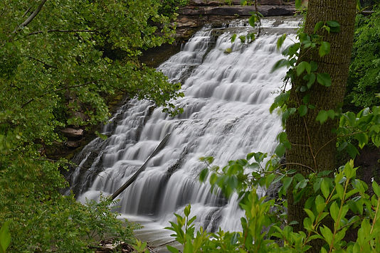
Description: Probably Ohio's most famous waterfall, Brandywine Falls is quite the sight. Easy access to such a large waterfall is always reason enough for a trip, and if you get here after a good rain, it will really be thundering.
Hiking Description: Park at the large and well signed Brandywine Falls parking area. The concrete trail begins in the northwestern corner of the lot. It goes down a few steps, then turns to boardwalk. The trail will then curve around to be headed east, following the creek upstream from high above. You will start decending through more stairs, and get under a bluffline. This is all boardwalk, and it continues all the way to a fantastic view of the falls at 0.2 miles. The trail continues to the brink of the falls, which is worth checking out.
Total Mileage: 0.4 total
Difficulty: 2/10 (Easy)
Date First Visited: May 29, 2021
Date Last Visited: December 11, 2021
Rank: A+

Moderate flow in May
_1_JPG.jpg)
High flow in December
Chagrin Falls
Description: Some people may be turned off at how urban this waterfall is, as it is right in the downtown of the city of the same name. However, I found this to be no problem at all, and there are lots of shops and restaurants within short walking distance of the falls, so this could be a real fun place to visit. Easy access to the falls itself, and to the downtown area.
Hiking Description: Park at this large parking lot here (41.430446, -81.392576). The trail begins in the northeastern section of the lot here (41.430894, -81.392154). The trail is a boardwalk which decends a few stairs right off and ends at a wonderful overlook almost immediately.
Total Mileage: 0.1 total
Difficulty: 2/10 (Easy)
Date First Visited: May 29, 2021
Date Last Visited: May 29, 2021
Rank: A

Cuyahoga Falls
Description: Another waterfall located in a city of the same name, Cuyahoga Falls isn't very big, but the surrounding woods are pretty, and the access is very easy. It also flows year-round, so you don't have to plan around rain.
Hiking Description: Parallel park on Front Street in downtown Cuyahoga Falls, near here (41.131000, -81.483672). You are right next to High Bridge Glens, which is the park where the waterfall is at. There is a wide sidewalk heading east, away from Front Street, right in the middle of this small park. Locate this trail and walk on it for a whole of 100 feet, you will come to a large bridge over the Cuyahoga River, with the falls off a little ways to your left. It's kind of far away, so a good zoom lens will help. The trail dead ends at the other side of the bridge, but there is a trail that leads to a nice overlook of the river. This trail was on your right just before the bridge.
Total Mileage: <0.1 total
Difficulty: 1/10 (Easy)
Date First Visited: October 24, 2021
Date Last Visited: October 24, 2021
Rank: B+

East and West Falls of Cascade (2)
Description: There are two waterfalls that collectively make up the "Falls of Cascade": East Falls and West Falls. Most would agree that West Falls is the more impressive of the two, but East Falls suffers from restricted accessibility and a dam atop the falls. Either way, they are both worth visiting, as they are really close together. You will want to park in two different spots for the two different falls, as I will explain below:
East Falls:
Park in the East Falls lot here (41.368976, -82.108079). The short trail to the overlook starts on the west side of the lot, and is only 200 feet long. You can hear the falls from where you parked.
Total Mileage: 0.1 total
Difficulty: 1/10 (Easy)
-----
West Falls:
This one has an actual hike to it, but it's still easy, and makes the falls more rewarding. The nearest parking lot to the trailhead is here (41.376323, -82.108880). This is kind of unfortunate because you will have to backtrack a bit to get to the trail. Head out on the path/sidewalk following Cascade Street back the way you drove in (south). As you begin to wrap around the large curve in the road, you will see a dirt trail splitting off. You could hike in this way, but it is more difficult and longer, and the easier way is just beyond. Continuing around the curve, you will soon see a concrete trail heading off into the woods. This is the easy way to get to the falls, so make the turn. This trail split is located here (41.375201, -82.110190). It is a rather uninteresting 0.25 mile walk from here to the falls. Just before you arrive, you will seee a large bridge crossing the river, but views are restricted from here. If you continue down th trail just 200 feet further, it will dead end at an awesome overlook of the falls that is very close to it. I was getting sprayed with mist standing there. Note that while the falls is within spitting distance of Lake Avenue, there is no formal access from there.
Total Mileage: 0.8 total
Difficulty: 2/10 (Easy)
Date First Visited: May 29, 2021
Date Last Visited: May 29, 2021
Rank: A+

East Falls

West Falls
Great Falls of Tinkers Creek
Description: Here's a complex and wild looking waterfall that is actually deep in the city. Easy access leads to this large fall. Access is restricted to the top, but it's easy to get better views if you're willing to be a bit rebellious. The photo I took is from this restricted area, and allegedly I could be prosecuted for going down there. You can decide for yourself.
Hiking Description: Start at Viaduct Park here (41.385382, -81.534225). Two trails leave from here: the first being a short trail to an old bridge near the viaduct, and the second, which goes to the falls. Take this second trail, which starts in the southeastern corner of the lot. The trail is paved all the way to the falls. After a leisurely 0.2 miles, you will come to a split. The trail makes a balloon loop from here, and it doesn't matter which way you go. In either direction, you will reach the falls by 0.3 from the parking lot. A short spur trail just downstream of the falls leads to the river and views of the viaduct, which is interesting. For those wanting better views of the falls, look for some bootpaths near the overlook of the falls. This is prohibited, but not enforced, and it's pretty easy to get closer.
Total Milage: 0.6 total
Difficulty: 2/10 (Easy)
Date First Visited: May 29, 2021
Date Last Visited: May 29, 2021
Rank: A+

Lanterman's Mill
Description: Lanterman's Mill is a historic mill with a scenic waterfall right next to the road. Easy access to the falls.
Hiking Description: The closest parking lot is here (41.067570, -80.683883). Upon leaving your car, head to the sidewalk on Park Drive, heading east towards Highway 62 and the mill. Cross the street at the light, and once at the other side, take a right following the sidewalk south on the east side of Highway 62. This leads high above the river on the Canfield Bridge, with a clear view of the falls. Don't stop there though, as if you head back to the light, there is a trail to the right that goes down to the falls and mill. More great views can be found here, and you can hook up with the Gorge Trail. There aren't any more falls found by following this, but it is scenic. The picture provided is from atop the Canfield Bridge.
Total Milage: 0.2 total
Difficulty: 1/10 (Easy)
Date First Visited: December 11, 2021
Date Last Visited: December 11, 2021
Rank: B+

Mill Creek Falls
Description: Mill Creek Falls is an impressive waterfall that would be even better if it had a better vantage point to view from. Even still, the views are good, and the access is easy to this inner city waterfall.
Hiking Description: Park at the small lot for Mill Creek Park here (41.444495, -81.626763). If you head east up Webb Terrace (the way you came in), there is a sidewlak that leads to a view of the waterfall from the side from up close. The trail stays close to the road until you get near to the waterfall, then goes down a short staircase. There is one more easily attainable view of the falls to be had here, so head pack to the parking lot. Once back, you should see a paved trail heading north. Almost immediately, you will arrive at this structure of sorts, and you can see the falls through the distance. It is pretty far away now, but you can get a good shot with a lens with good zoom.
Total Milage: 0.2 total
Difficulty: 1/10 (Easy)
Date First Visited: May 29, 2021
Date Last Visited: May 29, 2021
Rank: B
Paine Falls
Description: I initially thought Paine Falls wasn't even worth visiting, but for whatever reason, I decided to make a visit, and I'm glad I did. It's just outside of Cleveland, so it's close to town, but it's rural enough to feel wild. Easy access to the picturesque falls.
Hiking Description: Park at the small lot here (41.717815, -81.144148), and head out on the short trail to the falls, which starts in the south of the lot. It's an easy 0.1 mile stroll to the overlook of the falls between the trees. This is a great spot for foliage, so be sure to visit before the leaves have gone.
Total Milage: 0.2 total
Difficulty: 1/10 (Easy)
Date First Visited: May 29, 2021
Date Last Visited: May 29, 2021
Rank: A-
