Waterfalls in Pennsylvania
After a long hiatus, I have returned to Pennsylvania, and I had a great time. i still have only scratched the surface of the many, many waterfalls in this state, and hopefully I'll be returning again soon.
Northwest Pennsylvania
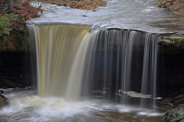
Big Run Falls
Description: Big Run Falls is a nice waterfall in a quaint city park. Easy access to the top (where the photo was taken from).
Hiking Description: Park here: (40.977009, -80.318610). Walk on the road for a short distance headed west. You will pass by the top of the falls after 200 feet, but the best view (pictured below) will be found after 500 feet.
Total Mileage: 0.2 total
Difficulty: 1/10 (Easy)
Date First Visited: December 11, 2021
Date Last Visited: December 11, 2021
Rank: A-
Homewood Falls
Description: I really liked Homewood Falls since you can walk behind it, and the hike is simple, but scenic. It's not massive by any means, but it has character, and I think it's a great place to visit, especially after rain. Note that it is also called Buttermilk Falls.
Hiking Description: There is a bit of room to park here: (40.813144, -80.325837), which is the closest spot to the trailhead. If that's full, head up the road and park here: (40.814599, -80.326766). From the first mentioned parking lot, head west on the dirt trail which quickly starts heading up the gorge of Clarks Run. The run is far below you here, but as you continue down the trail, which is mostly flat, the creek will get nearer to your level. Soon, you will go down some stairs and get beneath a small bluffline. The trail gets rockier here, but the falls is within sight. If you continue on (turns to boulder scrambling by this point), you can get behind the waterfall and over to the other side of the creek. Very beautiful area.
Total Mileage: 0.2 total
Difficulty: 3/10 (Easy)
Date First Visited: December 11, 2021
Date Last Visited: December 11, 2021
Rank: A+


Laurel Highlands
Buttermilk Falls

Description: Buttermilk Falls is a very nice waterfall that has been turned into a wonderful park just a few years ago back in 2017. The trail to the top of the falls is easy and paved, and a well-constructed boardwalk leads to the base and behind the falls. There is some interesting history here too.
Hiking Description: Start in the parking area at the end of the road here (40.418989, -79.067862). The trail heads south from here, passing a clearing, and then entering the woods. The walking is uninteresting for a few minutes, but then the trail will wrap around to the left and begin heading on a gentle downhill. You can tell that the land to your right goes down quite some distance. At about 0.2 miles, you will come to an overlook of the falls from above. It is somewhat obscured, but you can see the trail that leads to the bottom from here. If you continue on, you'll go down some stairs, and cross a rather extravagent bridge over the small stream. After this, the trail winds down a solid 100 or so stairs to the bottom of the falls. Watch out because it gets pretty incredible down there. The trail continues halfway behind the falls and dead-ends, but it lets you get far enough around to fully enjoy the falls. If water levels are up, water will pour directly on to the trail, so you may want to bring an umbrella. The only problem with this place is that you can't get a view of the falls that doesn't include the fences along the trail, but I'd say it's worth it because this lets you get so close to the falls.
Total Mileage: 0.5 total
Difficulty: 3/10 (Easy)
Date First Visited: August 9, 2024
Date Last Visited: August 9, 2024
Rank: A
Hinckston Road Falls
Description: The aptly named Hinckston Road Falls is found along Hinckston Road in Johnstown. The falls is not entirely natural, as it is the outflow of Hinckston Reservoir, but it really is something to see. The photo provided was taken from the side of the road - you can see this one without getting out of the car. Make sure you don't leave the road while you're here, because that is private property, and there was a cop patrolling the area. He was a real nice guy and I chatted with him for a while about the area, but it just shows you that they mean business about this property. Enjoy.
Hiking Description: Roll down the window and gaze.
Total Mileage: N/A
Difficulty: 0/10 (Roadside)
Date First Visited: August 9, 2024
Date Last Visited: August 9, 2024
Rank: A-

Ohiopyle State Park
Cucumber Falls
Description: Cucumber Falls is one of the more famous waterfalls in Ohiopyle Park, along with Ohiopyle Falls itself and Fallingwater, and for good reason. Cucumber Falls is one of the most picture perfect waterfalls in all of PA. We were here at somewhat low water, but it still looked fantastic, and we had a wonderful time exploring the area and wading the creek. I plan to return someday during higher water to see it in a different perspective, and also to visit the lesser known waterfalls in the park.
Hiking Description: Park in the well signed parking area here (39.862784, -79.502691). The trail starts on the north side of the lot, heading out on a wide trail. Very quickly, you will come to a split. To the left is a bridge over the creek, and to the right is the trail to the base of the falls. This will go down a few stairs, and lead to a decent view of the falls from above, then it will wind down to the bottom of the falls. To get the best views, you will have to do some boulder scrambling. I waded to the other side of the creek (right photo), and it's very pretty over there too. you can even get behind the falls with some effort.
Total Mileage: 0.2 total
Difficulty: 3/10 (Easy)
Date First Visited: August 9, 2024
Date Last Visited: August 9, 2024
Rank: A+


Ohiopyle Falls
Description: Ohiopyle Falls is a high volume waterfall found in it's namesake park that is an impressive sight. There are two ways to view it: a paved trail near the park visitor center, or a more rugged hike along the Ferncliff Peninsula. Both views are great, but the trail on the peninsula is sketchy in spots, so you decide.
Hiking Description: To get to the easy views, park here at the visitor center (39.868150, -79.494407). Just over to your west is a paved trail that quickly leads to a large wooden observation deck. This view is seen in the left photo. You can also get a view from the other side by hiking the trail around the Ferncliff Peninsula. Start this trail here (39.872033, -79.494185). The trail heads south, and is very easy and flat at first. You will go under a massive bridg; this is the Great Allegheny Passage, a popular rail trail. A short distance past the bridge, you will reach a trail split. You've been hiking on a short spur, and the trail you've just reached is the loop around the peninsula. Head left here. The trail stays flat and easy, and then you will approach the river. You get within a few feet of the river, and this is where the trail starts to get tricky. The trail will follow very close to the water's edge, and there is no real trail, you're just walking on the rocky riverbank. It's still flat, but these rocks can be slick, and the footing is uneven. The trail is blazed in yellow, and on these rocky sections, yellow paint is splotched on the rocky ground, which I thought was pretty interesting, and also really useful. Eventually, you will come to the brink of the falls. I wouldn't get to close to the edge of that if I were you, as there aren't any fences. From here, the trail enters the woods on a short, steep ascent, then flattens for just a bit, when you'll see a sign saying "Falls Overlook" pointing to the left. This spur goes down a few stairs, and you'll have your view (right photo).
Total Mileage: <0.1 total from visitor center, 0.6 total on Peninsula Trail
Difficulty: 1/10 (Easy) from visitor center, 4/10 (Moderate) from Peninsula Trail
Date First Visited: August 9, 2024
Date Last Visited: August 9, 2024
Rank: A-

